


It’s finally 80 degrees. That means the “what to do in summer while in NYC” lists are budding like dandelions. Most clever list creators inevitably write a variation of “leave NYC and visit Town X upstate” as a top NYC-based activity.
This annually sparks the debate of what defines “upstate.” Is it north of New York City, Westchester, or Dutchess County? Do we even consider the other side of the Hudson? How do Buffalo or Rochester fit in to the equation?
I am someone who spent half his life split almost evenly between upstate and downstate, and I have strong opinions. I am sure you do too.
Today 2xParked will be removing personal feelings by taking a data-based approach to answer this century old question1. (Thank you for this suggestion from an avid reader. Always happy to receive more thoughts and suggestions at 2xParked@gmail.com).

People’s Choice Boundary
The debate is most often defined by county, so I first looked at which counties are considered “downstate.” In a 2016 poll of New Yorkers, the most common response to how people define upstate New York was “everything north of Westchester County.” This beat out “north of Poughkeepsie” and “north of New York City.”

In this view, Westchester and Rockland County would then both be considered downstate.
Geometric Boundary
I don’t like the “People’s Choice Boundary” definition.
It is based off of sentiment rather than actual data. Sentiment has its place in the data world, but this sentiment is based off of “how I feel” without a “why” component.
The survey lacked nuance. Imagine if someone considered Putnam County the border. When the potential answers are predefined as “north of Westchester” or “north of Poughkeepsie”, “north of Putnam” advocates are forced to choose a suboptimal choice.
This survey was from 2016. Since then we have had a pandemic which further shifted downstate to upstate. How should this play into the equation?
I used 2018-2022 ACS data, like in the last edition, to investigate regional similarity at a zip code level to define a border from a geometric perspective. I tried to find a single line of latitude to separate upstate from downstate, similar to much of the US-Canada border. This means adjusting from an arbitrary definition (north of Westchester) based off of arbitrary borders (counties) to a data-defined methodology.
I looked at every possible line of latitude covering New York State. This includes lines going through the Adirondacks and lines going through Brooklyn; everything should be considered. For each line, I defined below the line as downstate and above as upstate. At each line drawn I compared the race/ethnicity, income, occupation, and social value of that version of upstate vs downstate. The line which produced the largest difference between the two regions is what I would consider the border.
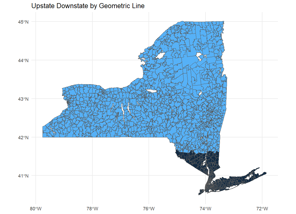
41.60N is a the border definition from a latitude perspective. This means Poughkeepsie and Monticello would be considered upstate, while Newburgh, Middletown and Beacon would be considered downstate. Wappinger Falls is right on the border.
Political/Cultural Boundary
Another common way boundaries between geographic regions are drawn are due to political or cultural differences.
Race/ethnicity, income, occupation, and social values are among the best predictors of political orientation. I created a baseline zone assuming NYC and Long Island should be considered downstate New York. I then crept northward, zip-by-zip, to see if each zip code was more similar to the downstate zone or the rest of New York. If more similar to downstate, I considered that zip to be downstate. As we traveled north, we would find zip codes more similar to upstate than downstate. I made the decision when two zip codes in a row were not similar to downstate which bordered a downstate zip code, that would define the border.

This gives my favorite view of the debate. I love the asymmetry, especially when you look at east and west of the Hudson River. Considering all the migration to the east of the Hudson — aided by Amtrak and Metro-North — this should not be a surprise.
Case Closed?
There were limited natural borders such as rivers or mountains — likely the most common border drawing tool— cutting through New York State, so I was unable to give a good suggestion from this perspective. Instead, I stuck to using three other common border methodologies between existing towns, states, and countries.
A definition like “north of Westchester” has the easiest and most stable definition, but it might not actually be reflective of reality. For example, if I looked at the data from 5 years ago (ACS 2013-2017), we find the Geometric border between upstate and downstate would have been slightly more south at 41.55N. This indicates downstate has permeated northward in a small but significant way over the past half-decade.
In 5 more years when the Simpsons write another parody making fun of upstate New York, who will be offended? Only time and data will tell.
According to Google Ngrams, which looks at the frequency of certain words and phrases published since 1800, “upstate New York” first started being used in the 1930s.
I feel like it should follow the commuting zone to NYC, which is closest to the last map + max commuting time of 1.5 - 2 hours.